The Beidou Satellite Network and the “Space Silk Road” in Eurasia
The Beidou Satellite Network and the “Space Silk Road” in Eurasia
Author’s note: This article was informed by research and analysis on the PRC’s Beidou satellite program conducted by Pointe Bello, a strategic intelligence and advisory firm.
Introduction
On June 23, a Long March-3B carrier rocket was successfully launched from the Xichang Satellite Launch Center in Sichuan Province, carrying with it the latest satellite of the Beidou (“Big Dipper”) Global Satellite Navigation System (北斗全球卫星导航系统, Beidou Quanqiu Weixing Daohang Xitong). This launch was a capstone event in an ambitious series of satellite launches conducted by the People’s Republic of China (PRC) throughout the early months of 2020 (China Brief, May 15). The June 23 launch delivered into orbit the 30th and final satellite of the Beidou third-generation constellation (and the 55th Beidou satellite overall), reportedly completing the third-generation network six months ahead of the original timetable (Beidou.gov.cn, June 23). The launch was hailed in PRC state media as “a complete success,” and “a milestone in the nation’s space endeavor” (Xinhua, June 23; Xinhua, June 24).
The Beidou third-generation constellation (hereafter, “Beidou-3”) consists of: 3 satellites in geostationary orbit (GEO); 24 satellites in middle earth orbit (MEO); and 3 satellites in inclined geosynchronous orbit (IGSO) (China Satellite Navigation Office, December 2017; Xinhua, June 23). Beidou-3 represents a noteworthy advancement over the capabilities of the earlier first- and second-generation Beidou satellite navigation networks. [1] Per official PRC information issued in December 2018—when Beidou-3 was proclaimed to be operational, if not yet complete—the system offers positioning accuracy within 10 meters horizontal and 10 meters vertical (5 meters in the Asia-Pacific Region); a velocity measurement accuracy within 0.2 meters per second; and a timing accuracy of 20 nanoseconds. [2]
The completion of the third-generation Beidou system is a development with significant implications for the PRC’s military capabilities. Like the U.S. Global Positioning System (GPS) and the Russian GLONASS network, Beidou was originally created for military purposes: the impetus for the program dates back to the 1990s, when People’s Liberation Army (PLA) planners realized their dependence on the U.S.-controlled GPS network. [3] In recent years, the PRC has actively sought to promote the image of Beidou as a civilian-led program intended primarily for commercial and scientific purposes; however, the program is under overall military direction, with the PLA in charge of Beidou’s senior-most program management organizations. [4]
Beidou as a Component of the BRI and the “Space Silk Road”
Military and commercial applications aside, Beidou is also serving a key role in the PRC’s diplomatic outreach and geopolitical presence in Eurasia. PRC propaganda has gone to great lengths to promote expanding usage of Beidou as a key component of the Belt and Road Initiative (BRI), and to market Beidou services to clients—both commercial and national—throughout Central and South Asia. This aspect of Beidou is frequently encapsulated under the slogans of building an “Information Silk Road” (信息丝绸之路, Xinxi Sichou zhi Lu), a “Digital Silk Road” (数字丝绸之路, Shuzi Sichou zhi Lu), or a “Space Silk Road” (太空丝绸之路, Taikong Sichou zhi Lu) throughout Asia—and then onwards to Europe and Africa (Renmin Luntan, May 10, 2017; Zhongguo Duiwai Maoyi Zazhi, February 8, 2019).
These themes date back to at least 2016, when the PRC issued its white paper China’s BeiDou Navigation Satellite System. In that document, the PRC asserted that “China applies the principle that ‘[Beidou] is developed by China, and dedicated to the world’ to serve the development of the Silk Road Economic Belt and the 21st Century Maritime Silk Road” (Beidou White Paper, June 2016, Preface). The document further predicted that “In line with the [BRI], China will jointly build satellite navigation augmentation systems with relevant nations, provide highly accurate satellite navigation, positioning and timing services, improve the overseas [Beidou] service performances, and promote international applications of navigation technologies” (Beidou White Paper, June 2016, Section V).
The PRC’s official English-language propaganda website for the BRI has reiterated these themes, stating that Beidou “is of significant importance for China’s Going Global strategy and the [BRI]… Within the BRI, [Beidou] is a part of China’s Space Silk Road [which] aims at creating an entire range of space capabilities including satellites, launch services, and ground infrastructure and at supporting related industries and service providers going global” (BRI Official Website, 2018). As its satellite navigation network has developed in recent years, the PRC has offered prioritized (and free) access to Beidou data and services to BRI member nations—thereby providing an additional incentive for countries to sign on with the PRC’s signature foreign policy initiative. As stated in a recent research report for the U.S. Congress performed by Pointe Bello and the Project 2049 Institute, “In offering Beidou to [BRI] partners, the PRC is undoubtedly attempting to gain influence as a regional technological power.” [5]
China and International Partnerships in Promoting Beidou in Eurasia
Sino-Russian Collaboration on Satellite Navigation
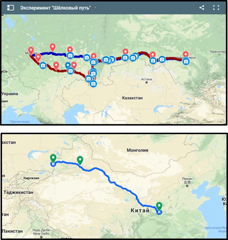
The PRC is actively seeking to engage with international partners in promoting Beidou services as a vanguard component of this new “Information Silk Road” through Central and South Asia. Russia became one of the PRC’s key partners when the “Russia-China Project Committee on Important Strategic Cooperation in Satellite Navigation” (中俄卫星导航重大战略合作项目委员会 / Zhong-E Weixing Daohang Zhongda Zhanlue Hezuo Xiangmu Weiyuanhui) was first formed in January 2014 (Beidou.gov.cn, July 11, 2018). Between 2015 and 2017, Chinese and Russian representatives signed a series of agreements pertaining to the sharing of Beidou and GLONASS data—as well as the joint development of navigation products to be marketed in the states of the Shanghai Cooperation Organization (SCO) and countries connected to the BRI. This culminated in a July 2017 agreement to create a “Silk Road Experiment,” or “Silk Way,” for the sharing of civil application GLONASS-Beidou data in a corridor through central Russia (see images below) (Sputnik News, December 16, 2015; GLONASS Official Website, undated).
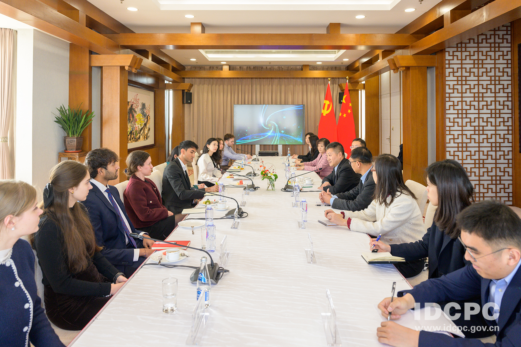
Russia and the PRC have held high-level annual meetings of the “Project Committee” since its founding in 2014, with the venue shifting year-by-year between the two countries. The fifth annual meeting was held in Beijing in September 2018, and was chaired by Wang Zhaoyao (王兆耀), who serves a senior role (and a dual military-civilian role) in managing the Beidou program within the PRC (see photos below, and endnote #4). (Yidian Zixun, October 18, 2018). The sixth and most recent meeting of the committee was held in the Russian city of Kazan in late August 2019. In coverage of this meeting, PRC state press praised the achievements of Sino-Russian cooperation in conducting surveys of locations for “satellite navigation monitoring stations” (卫星导航监测站, weixing daohang jiance zhan); success in jointly developing “global satellite navigation system signal multi-mode, multi-frequency chips” (卫星导航系统全球信号多模多频射频芯片, weixing daohang xitong quanqiu xinhao duomo duopin shepin xinpian); and in “jointly developing [Beidou-GLONASS] “functions and testing to service the BRI” (联合开展两系统“一带一路”服务性能测试等, lianhe kaizhan liang xitong “Yi Dai Yi Lu” fuwu xingneng ceshi) (Xinhua, September 3, 2019).
The official outlets of the two governments have maintained consistently positive coverage of their collaborative efforts in satellite navigation—and Russian state media went so far as to claim in April 2018 that the Beidou and GLONASS systems would be integrated into a combined network offering worldwide coverage (RT, April 1, 2018). Given the military significance of satellite positioning systems, as well as their extensive commercial applications, it appears unlikely that the two sides would ever truly agree to such a complete merger of their networks. Technical cooperation in particular areas, however, is likely to continue.
Satellite Navigation Technology Outreach in the Middle East
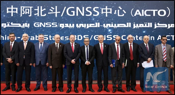
A second prominent example of the PRC’s Beidou diplomacy is the effort to promote the system in the Middle East. The PRC first hosted a “China-Arab States BeiDou Cooperation Forum” (中阿北斗合作论坛, Zhong-Ah Beidou Hezuo Luntan) in Shanghai in May 2017 (Xinhua, April 2, 2019). This was followed by the creation of a “China-Arab States BDS/GNSS Center” (“BDS” for Beidou, and “GNSS” for “global navigation satellite system”), which opened its doors in Tunis, Tunisia in April 2018. This institution, hailed in PRC media as “the first overseas center for China’s indigenous BeiDou Navigation Satellite System,” was established as a joint project between the PRC and the Arab Information and Communication Technology Organization (AICTO), an organization subordinate to the Arab League (Xinhua, April 11, 2018).
PRC state media has touted the center’s value as “a window to showcase the BDS, and a platform for promoting international exchanges and cooperation” between China and countries in the Middle East. It has also cited persons affiliated with the center to promote the benefits of Beidou for Middle Eastern countries. Xinhua has quoted Mohamed Ben Amor, the secretary-general of AICTO, as vowing to “intensify… cooperation with China in the field of satellite navigation to boost technological advance[s] and economic development in the region” (Xinhua, April 11, 2018); and Slim Khalbous, Tunisian Minister of Higher Education, as calling Beidou “the best example for the strategic cooperation between China and Arab states, as satellite navigation integrates many high-tech areas, including telecommunication and space technologies” (Xinhua, April 2, 2019).
The early months of 2019 were a noteworthy period for such collaborative efforts to develop Beidou capabilities. From January to March 2019, AICTO and officials from the China Satellite Navigation Office “jointly carried out test and evaluation activities of [Beidou]… including static testing and dynamics [throughout] the main areas of the Arab region” (Beidou.gov.cn, April 2019). This was capped off by a second PRC-Arab States BeiDou Forum, which was held in Tunis in April (Xinhua, April 2, 2019). Similar to previous engagements, much of the agenda focused on the potential benefits of Beidou for agriculture in the Middle East and North Africa—to include demonstration of a self-driving tractor maneuvering through the streets of Tunis (UN Office for Outer Space Affairs, November 2018; Xinhua, April 2, 2019).

Conclusion
For the past quarter-century, the Beidou Global Satellite Navigation System has been one of the PRC’s highest-priority technology development programs. The successful completion of the network has significant implications for Chinese military capabilities, commercial competitiveness, and geopolitical freedom of movement vis-à-vis the United States and Europe. However, the examples profiled above—only a partial picture of the PRC’s Beidou technology and diplomatic outreach—demonstrate how the system is also serving a key role in the PRC’s geopolitical ambitions to expand the Belt and Road Initiative. Although the substance behinds its slogans might be debatable, Beijing clearly intends to promote Beidou as a worldwide alternative to the U.S. GPS network—and to use the “Space Silk Road” as another channel to expand its influence throughout Eurasia, and beyond.
John Dotson is the editor of China Brief. For any comments, queries, or submissions, feel free to reach out to him at: cbeditor@jamestown.org.
Notes
[1] The Beidou Mark 1 (北斗一号系统, Beidou Yi Hao Xitong) constellation became operational in 2003, and possessed a reported locational accuracy within 20 meters, as well as a short message service (SMS) communications function that enabled the transmission of short messages of 120 Chinese characters. The Beidou Mark 2 (北斗二号系统, Beidou Er Hao Xitong) constellation became operational in December 2011 with a network of 10 satellites; it offered velocity, timing, and location services (with reported positioning accuracies of up to 10 meters), as well as the SMS function. [See: Pollpeter, Besha, and Krolikowski, “The Research, Development, and Acquisition Process for the Beidou Navigation Satellite Programs,” University of California Institute on Global Conflict and Cooperation policy paper (Jan. 7, 2014), https://scholar.harvard.edu/files/alannak/files/beidou_rda_pb.pdf; and “China GPS Rival Beidou Starts Offering Navigation Data,” BBC News Online, March 8, 2012, https://www.bbc.com/news/technology-16337648.]
[2] “The BDS-3 Preliminary System Is Completed to Provide Global Services,” Beidou.gov.cn (official PRC information website for Beidou, in English), December 27, 2018. https://en.beidou.gov.cn/WHATSNEWS/201812/t20181227_16837.html.
[3] See: Minnie Chan, “’Unforgettable Humiliation’ Led to Development of GPS Equivalent,” South China Morning Post, Nov. 13, 2009, https://www.scmp.com/article/698161/unforgettable-humiliation-led-development-gps-equivalent; and “Beidou Equipment Covers Most Operational Units of Regimental Level and Above” (北斗装备覆盖大部分团以上作战部队, Beidou Zhuangbei Fugai Dabufen Tuanyishang Zuozhan Budui), People’s Daily Online, undated, https://military.people.com.cn/GB/8221/71065/370766/; and Kevin Pollpeter, “To Be More Precise: The Beidou Satellite Navigation and Positioning System,” China Brief, Vol. 7 Issue 10 (May 25, 2007), http://jamestown.org/program/to-be-more-precise-the-beidou-satellite-navigation-and-positioning-system/.
[4] Research performed by the author in 2018-2019 turned up multiple points of evidence to indicate that the PLA exercises primary control over the Beidou program. For example, the nominally civilian China Satellite Navigation Systems Committee (中国卫星导航系统委员会, Zhongguo Weixing Daohang Xitong Weiyuanhui), or CSNSC, often serves as the public face of the Beidou program. However, the CSNSC appears to operate as a public relations front organization for the CCP Central Military Commission Equipment Development Department (中央军委装备发展部, Zhongyang Junwei Zhuangbei Fazhan Bu), or CMCEDD. Wang Zhaoyao (王兆耀), who has been the designated head of the CSNSC since September 2018 (as a nominal civilian), is a PLA major general who also serves concurrently as the deputy head of the CMCEDD. [See: “The Satellite Navigation Committee’s New Chairman” (中国卫星导航系统委员会的新主席), Yidian Zixun, October 18, 2018. https://www.yidianzixun.com/article/0KI63cZS.] The author may respond to further inquiries on this subject upon request. For further discussion of the PLA’s role in the Beidou program, see also: Stokes, Alvarado, Weinstein, and Easton, China’s Space and Counterspace Capabilities and Activities, report by the Project 2049 Institute and Pointe Bello on behalf of the U.S.-China Economic and Security Review Commission (March 2020), pp. 12-13. https://www.uscc.gov/sites/default/files/2020-05/China_Space_and_Counterspace_Activities.pdf.
[5] Stokes, Alvarado, Weinstein, and Easton, China’s Space and Counterspace Capabilities and Activities, report by the Project 2049 Institute and Pointe Bello on behalf of the U.S.-China Economic and Security Review Commission (March 2020), p. 88. https://www.uscc.gov/sites/default/files/2020-05/China_Space_and_Counterspace_Activities.pdf.